
Maçanet de la Selva topographic map
Interactive map
Click on the map to display elevation.
About this map
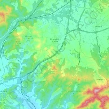
Name: Maçanet de la Selva topographic map, elevation, terrain.
Location: Maçanet de la Selva, Selva, Gerona, Catalonië, 17412, Spanje (41.73498 2.66938 41.79591 2.78949)
Average elevation: 338 ft
Minimum elevation: 95 ft
Maximum elevation: 1,037 ft
Other topographic maps
Click on a map to view its topography, its elevation and its terrain.
Martossa
Spanje > Catalonië > Selva > Tossa de Mar > Santa Maria de Llorell
Martossa, Santa Maria de Llorell, Tossa de Mar, Selva, Gerona, Catalonië, 17320, Spanje
Average elevation: 207 ft
Lloret de Mar
Spanje > Catalonië > Selva > Lloret de Mar
Lloret de Mar, Selva, Gerona, Catalonië, 17310, Spanje
Average elevation: 410 ft
Tossa de Mar
Tossa de Mar, Selva, Gerona, Catalonië, 17320, Spanje
Average elevation: 440 ft