
Fellaoucene topographic map
Interactive map
Click on the map to display elevation.
About this map
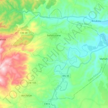
Name: Fellaoucene topographic map, elevation, terrain.
Location: Fellaoucene, Daïra Fellaoucene, Tlemcen, Algérie (34.96151 -1.66188 35.06550 -1.51004)
Average elevation: 1,001 ft
Minimum elevation: 384 ft
Maximum elevation: 2,572 ft
Other topographic maps
Click on a map to view its topography, its elevation and its terrain.
Aïn Fetah
Algérie > Tlemcen > Daïra Fellaoucene
Aïn Fetah, Daïra Fellaoucene, Tlemcen, Algérie
Average elevation: 1,319 ft
Aïn Kebira
Algérie > Tlemcen > Daïra Fellaoucene > Aïn Kebira
Aïn Kebira, Daïra Fellaoucene, Tlemcen, Algérie
Average elevation: 1,526 ft