
Herzogenbuchsee topographic map
Interactive map
Click on the map to display elevation.
About this map
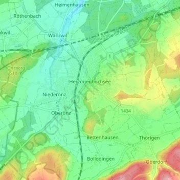
Name: Herzogenbuchsee topographic map, elevation, terrain.
Average elevation: 1,591 ft
Minimum elevation: 1,437 ft
Maximum elevation: 1,932 ft
Of the built up area, industrial buildings made up 3.1% of the total area while housing and buildings made up 14.2% and transportation infrastructure made up 7.5%. while parks, green belts and sports fields made up 1.5%. 34.0% of the total land area is heavily forested. Of the agricultural land, 30.9% is used for growing crops and 6.1% is pastures. All the water in the municipality is in rivers and streams. The elevation of the train station is 465 m (1,526 ft).
Other topographic maps
Click on a map to view its topography, its elevation and its terrain.
Rohrbach
Switzerland > Bern > Oberaargau administrative district
Rohrbach, Oberaargau administrative district, Emmental-Oberaargau administrative region, Bern, 4938, Switzerland
Average elevation: 2,090 ft