
Fadmoor topographic map
Interactive map
Click on the map to display elevation.
About this map
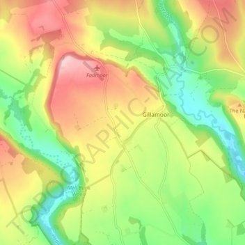
Name: Fadmoor topographic map, elevation, terrain.
Location: Fadmoor, Ryedale, North Yorkshire, England, United Kingdom (54.27633 -1.01769 54.32238 -0.95425)
Average elevation: 486 ft
Minimum elevation: 197 ft
Maximum elevation: 827 ft
Other topographic maps
Click on a map to view its topography, its elevation and its terrain.
Appleton-le-Moors
United Kingdom > England > North Yorkshire > Ryedale
Appleton-le-Moors, Ryedale, North Yorkshire, England, YO62 6TF, United Kingdom
Average elevation: 341 ft
Malton
United Kingdom > England > North Yorkshire > Ryedale > Malton
Malton, Ryedale, North Yorkshire, Yorkshire and the Humber, England, United Kingdom
Average elevation: 92 ft
Barton-le-Street
United Kingdom > England > North Yorkshire > Ryedale > Barton-le-Street
Barton-le-Street, Ryedale, North Yorkshire, Yorkshire and the Humber, England, United Kingdom
Average elevation: 141 ft