
Arles topographic map
Interactive map
Click on the map to display elevation.
About this map
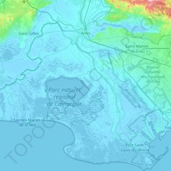
Name: Arles topographic map, elevation, terrain.
Average elevation: 43 ft
Minimum elevation: -16 ft
Maximum elevation: 1,270 ft
Other topographic maps
Click on a map to view its topography, its elevation and its terrain.
Marselha
França > Provença-Alpes-Costa Azul > Bouches-du-Rhône
Marselha, Marseille, Bouches-du-Rhône, Provença-Alpes-Costa Azul, França metropolitana, 13000, França
Average elevation: 308 ft
Maussane-les-Alpilles
França > Provença-Alpes-Costa Azul > Bouches-du-Rhône
Maussane-les-Alpilles, Arles, Bouches-du-Rhône, Provença-Alpes-Costa Azul, França metropolitana, 13520, França
Average elevation: 217 ft
Eygalières
França > Provença-Alpes-Costa Azul > Bouches-du-Rhône
Eygalières, Arles, Bouches-du-Rhône, Provença-Alpes-Costa Azul, França metropolitana, 13810, França
Average elevation: 466 ft