
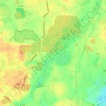
Schwienholm topographic map
Interactive map
Click on the map to display elevation.
About this map
Name: Schwienholm topographic map, elevation, terrain.
Average elevation: 128 ft
Minimum elevation: 62 ft
Maximum elevation: 184 ft
Other topographic maps
Click on a map to view its topography, its elevation and its terrain.
Kohlfeld
Deutschland > Schleswig-Holstein > Schleswig-Flensburg > Mittelangeln > Satrup
Kohlfeld, Satrup, Mittelangeln, Schleswig-Flensburg, Schleswig-Holstein, 24986, Deutschland
Average elevation: 118 ft
Mittelangeln
Deutschland > Schleswig-Holstein > Schleswig-Flensburg > Mittelangeln
Mittelangeln, Schleswig-Flensburg, Schleswig-Holstein, 24986, Deutschland
Average elevation: 121 ft
Obdrupholz
Deutschland > Schleswig-Holstein > Schleswig-Flensburg > Mittelangeln > Satrup
Obdrupholz, Satrup, Mittelangeln, Schleswig-Flensburg, Schleswig-Holstein, 24986, Deutschland
Average elevation: 121 ft
Satrup
Deutschland > Schleswig-Holstein > Schleswig-Flensburg > Mittelangeln
Satrup, Mittelangeln, Schleswig-Flensburg, Schleswig-Holstein, 24986, Deutschland
Average elevation: 121 ft