
Ouled Rahmoun topographic map
Interactive map
Click on the map to display elevation.
About this map
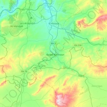
Name: Ouled Rahmoun topographic map, elevation, terrain.
Location: Ouled Rahmoun, Daïra El Khroub, Constantine, 25301, Algérie (36.09257 6.51271 36.27049 6.85954)
Average elevation: 2,667 ft
Minimum elevation: 1,785 ft
Maximum elevation: 4,823 ft
Other topographic maps
Click on a map to view its topography, its elevation and its terrain.
Ali Mendjeli
Algérie > Constantine > Daïra El Khroub
Ali Mendjeli, El Khroub, Daïra El Khroub, Constantine, 25005, Algérie
Average elevation: 2,451 ft
Charchar
Algérie > Constantine > Daïra El Khroub > El Khroub
Charchar, El Khroub, Daïra El Khroub, Constantine, 25100, Algérie
Average elevation: 2,008 ft
El Khroub
Algérie > Constantine > Daïra El Khroub
El Khroub, Daïra El Khroub, Constantine, Algérie
Average elevation: 2,523 ft
Oued Hammime
Algérie > Constantine > Daïra El Khroub > El Khroub
Oued Hammime, El Khroub, Daïra El Khroub, Constantine, Algérie
Average elevation: 2,247 ft
Aïn Smara
Algérie > Constantine > Daïra El Khroub
Aïn Smara, Daïra El Khroub, Constantine, Algérie
Average elevation: 2,510 ft
Chelia
Algérie > Constantine > Daïra El Khroub > El Khroub
Chelia, El Khroub, Daïra El Khroub, Constantine, 25040, Algérie
Average elevation: 2,047 ft