
吉阳山 topographic map
Interactive map
Click on the map to display elevation.
About this map
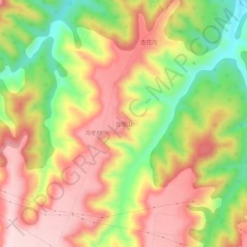
Name: 吉阳山 topographic map, elevation, terrain.
Location: 吉阳山, 灵台县, 平凉市, 甘肃省, 中国 (35.13700 107.53700 35.17700 107.57700)
Average elevation: 3,894 ft
Minimum elevation: 3,301 ft
Maximum elevation: 4,377 ft
Other topographic maps
Click on a map to view its topography, its elevation and its terrain.