Geolocate

Pettendorf topographic map

Click on the map to display elevation.

About this map

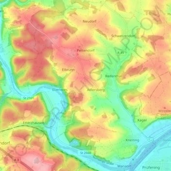
Name: Pettendorf topographic map, elevation, terrain.

Location: Pettendorf, Landkreis Regensburg, Bavaria, 93186, Germany (49.01493 11.96458 49.07629 12.04794)

Average elevation: 1,332 ft

Minimum elevation: 1,079 ft

Maximum elevation: 1,598 ft

Other topographic maps

Click on a map to view its topography, its elevation and its terrain.

Langenerling

Germany > Bavaria > Landkreis Regensburg

Average elevation: 1,165 ft

Eggmühl

Germany > Bavaria > Landkreis Regensburg

Average elevation: 1,253 ft

Wahlsdorf

Germany > Bavaria > Landkreis Regensburg

Average elevation: 1,427 ft

Gear up for your next adventure:

📱Solar Portable Charger - Solar power bank for charging devices off‑grid
📦Dry Bags Set - Waterproof storage for electronics and clothes
🏔️Mountain Trail Maps - High‑detail maps for popular peaks
🥾Hiking Shoes - Durable and comfortable shoes for trail hiking
🛠️Outdoor Gear Repair Kit - Essential tools to fix gear on the trail

As an Amazon Associate, this site earns from qualifying purchases at no extra cost to you.