
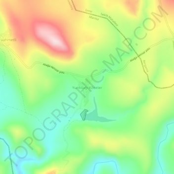
Yuntdağı Köseler topographic map
Interactive map
Click on the map to display elevation.
About this map
Name: Yuntdağı Köseler topographic map, elevation, terrain.
Location: Yuntdağı Köseler, Yunusemre, Manisa, Aegean Region, Turkey (38.83175 27.17975 38.87175 27.21975)
Average elevation: 886 ft
Minimum elevation: 423 ft
Maximum elevation: 1,539 ft
Other topographic maps
Click on a map to view its topography, its elevation and its terrain.
Merkez Efendi Mahallesi
Merkez Efendi Mahallesi, Yunusemre, Manisa, Aegean Region, Turkey
Average elevation: 364 ft