
Make a donation
Gear up for your next adventure:
As an Amazon Associate, this site earns from qualifying purchases at no extra cost to you.
Osmaniye topographic map
Click on the map to display elevation.
Make a donation
Gear up for your next adventure:
As an Amazon Associate, this site earns from qualifying purchases at no extra cost to you.
Osmaniye
Osmaniye (pronounced ) is a city in the Çukurova region of Turkey, the capital of Osmaniye Province. Area 3,767 km². Population of Osmaniye city: 219,339. Osmaniye Province: 512,804 (2014). Osmaniye is at an elevation of 125 meters (410.1 feet).
Make a donation
Gear up for your next adventure:
As an Amazon Associate, this site earns from qualifying purchases at no extra cost to you.
About this map
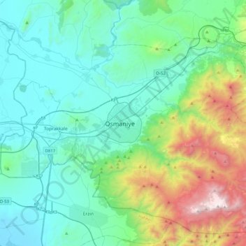
Name: Osmaniye topographic map, elevation, terrain.
Average elevation: 1,447 ft
Minimum elevation: -3 ft
Maximum elevation: 7,113 ft
Make a donation
Gear up for your next adventure:
As an Amazon Associate, this site earns from qualifying purchases at no extra cost to you.