
Ait Anzar topographic map
Interactive map
Click on the map to display elevation.
About this map
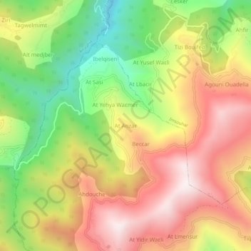
Name: Ait Anzar topographic map, elevation, terrain.
Average elevation: 3,064 ft
Minimum elevation: 1,552 ft
Maximum elevation: 4,469 ft
Other topographic maps
Click on a map to view its topography, its elevation and its terrain.
Laâzib Aït Ali
Algérie > Tizi Ouzou > Daïra Iferhounene > Iferhounene
Laâzib Aït Ali, Iferhounene, Daïra Iferhounene, Tizi Ouzou, 15013, Algérie
Average elevation: 3,268 ft
Bouaidel
Algérie > Tizi Ouzou > Daïra Iferhounene > Iferhounene
Bouaidel, Iferhounene, Daïra Iferhounene, Tizi Ouzou, 15037, Algérie
Average elevation: 2,608 ft
Tiruda
Algérie > Tizi Ouzou > Daïra Iferhounene > Iferhounene
Tiruda, Iferhounene, Daïra Iferhounene, Tizi Ouzou, Algérie
Average elevation: 4,826 ft
Bechar
Algérie > Tizi Ouzou > Daïra Iferhounene > Iferhounene > Bechar
Bechar, Iferhounene, Daïra Iferhounene, Tizi Ouzou, 15024, Algérie
Average elevation: 3,146 ft
Tirourda
Algérie > Tizi Ouzou > Daïra Iferhounene > Iferhounene
Tirourda, Iferhounene, Daïra Iferhounene, Tizi Ouzou, 15013, Algérie
Average elevation: 4,413 ft