
Knock Hill topographic map
Interactive map
Click on the map to display elevation.
About this map
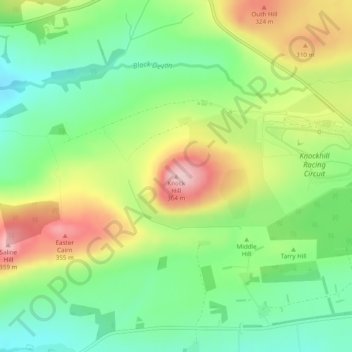
Name: Knock Hill topographic map, elevation, terrain.
Location: Knock Hill, Fife, Schottland, KY12 9LP, Vereinigtes Königreich (56.12734 -3.52485 56.12744 -3.52475)
Average elevation: 791 ft
Minimum elevation: 518 ft
Maximum elevation: 1,188 ft
Other topographic maps
Click on a map to view its topography, its elevation and its terrain.
East Lomond
Vereinigtes Königreich > Schottland > Fife > Falkland
East Lomond, Falkland, Fife, Schottland, KY6 3HG, Vereinigtes Königreich
Average elevation: 781 ft
Crail
Vereinigtes Königreich > Schottland > Fife
Crail, Fife, Schottland, KY10 3UG, Vereinigtes Königreich
Average elevation: 69 ft
Falkland
Vereinigtes Königreich > Schottland > Fife
Falkland, Fife, Schottland, KY15 7BU, Vereinigtes Königreich
Average elevation: 436 ft
St Andrews
Vereinigtes Königreich > Schottland > Fife
St Andrews, Fife, Schottland, KY16 9PA, Vereinigtes Königreich
Average elevation: 125 ft