
Pebble Beach topographic map
Click on the map to display elevation.
About this map
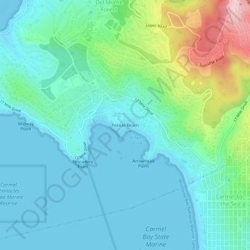
Name: Pebble Beach topographic map, elevation, terrain.
Average elevation: 174 ft
Minimum elevation: -16 ft
Maximum elevation: 810 ft
Monterey County trails, hiking, mountain biking, running and outdoor activities
Other topographic maps
Click on a map to view its topography, its elevation and its terrain.
Carmel Pinnacles State Marine Reserve
United States > California > Monterey County > Del Monte Forest
Average elevation: 7 ft