
Vernon topographic map
Interactive map
Click on the map to display elevation.
About this map
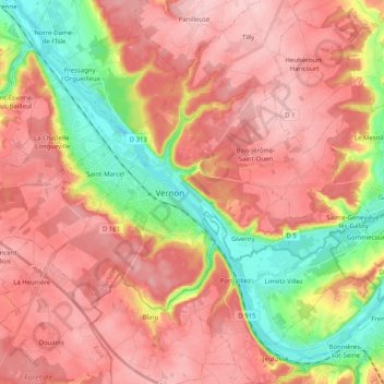
Name: Vernon topographic map, elevation, terrain.
Average elevation: 322 ft
Minimum elevation: 23 ft
Maximum elevation: 518 ft
Other topographic maps
Click on a map to view its topography, its elevation and its terrain.
Château de Bizy
Château de Bizy, Avenue du Maréchal de Lattre de Tassigny, La Demi Lune, Vernon, Les Andelys, Eure, Normandie, France métropolitaine, 27200, France
Average elevation: 256 ft