
Thank you for supporting this site ❤️
Make a donation
Make a donation
Gear up for your next adventure:
As an Amazon Associate, this site earns from qualifying purchases at no extra cost to you.
Korome topographic map
Click on the map to display elevation.
Thank you for supporting this site ❤️
Make a donation
Make a donation
Gear up for your next adventure:
As an Amazon Associate, this site earns from qualifying purchases at no extra cost to you.
About this map
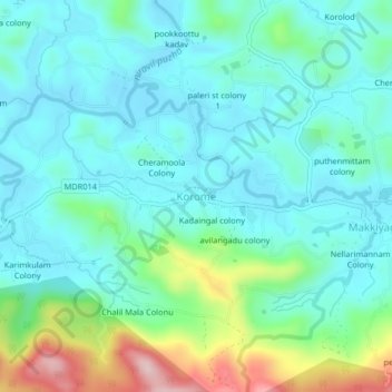
Name: Korome topographic map, elevation, terrain.
Location: Korome, Mananthavady, Wayanad District, Kerala, 670731, India (11.70438 75.84157 11.78438 75.92157)
Average elevation: 2,874 ft
Minimum elevation: 2,362 ft
Maximum elevation: 5,804 ft
Thank you for supporting this site ❤️
Make a donation
Make a donation
Gear up for your next adventure:
As an Amazon Associate, this site earns from qualifying purchases at no extra cost to you.