
Zerbst topographic map
Interactive map
Click on the map to display elevation.
About this map
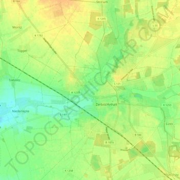
Name: Zerbst topographic map, elevation, terrain.
Average elevation: 233 ft
Minimum elevation: 184 ft
Maximum elevation: 276 ft
Other topographic maps
Click on a map to view its topography, its elevation and its terrain.
Lindau
Deutschland > Sachsen-Anhalt > Anhalt-Bitterfeld > Zerbst/Anhalt
Lindau, Zerbst/Anhalt, Anhalt-Bitterfeld, Sachsen-Anhalt, 39264, Deutschland
Average elevation: 259 ft
Luso
Deutschland > Sachsen-Anhalt > Anhalt-Bitterfeld > Zerbst/Anhalt
Luso, Zerbst/Anhalt, Anhalt-Bitterfeld, Sachsen-Anhalt, Deutschland
Average elevation: 262 ft
Deetz
Deutschland > Sachsen-Anhalt > Anhalt-Bitterfeld > Zerbst/Anhalt
Deetz, Zerbst/Anhalt, Anhalt-Bitterfeld, Sachsen-Anhalt, Deutschland
Average elevation: 295 ft
Steutz
Deutschland > Sachsen-Anhalt > Anhalt-Bitterfeld > Zerbst/Anhalt
Steutz, Zerbst/Anhalt, Anhalt-Bitterfeld, Sachsen-Anhalt, Deutschland
Average elevation: 217 ft