
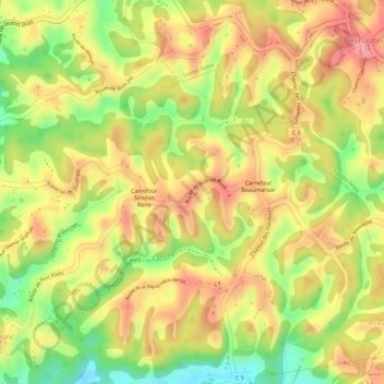
Bois-de-Rose topographic map
Interactive map
Click on the map to display elevation.
About this map
Name: Bois-de-Rose topographic map, elevation, terrain.
Average elevation: 279 ft
Minimum elevation: 69 ft
Maximum elevation: 417 ft
Other topographic maps
Click on a map to view its topography, its elevation and its terrain.
Pliane
France > Guadeloupe > Le Gosier > Pliane
Pliane, Le Gosier, Pointe-à-Pitre, Guadeloupe, 97190, France
Average elevation: 144 ft
Mare Gaillard
France > Guadeloupe > Le Gosier
Mare Gaillard, Le Gosier, Pointe-à-Pitre, Guadeloupe, 97190, France
Average elevation: 121 ft
Dampierre
France > Guadeloupe > Le Gosier
Dampierre, Le Gosier, Pointe-à-Pitre, Guadeloupe, 97190, France
Average elevation: 52 ft
Grand Bois
France > Guadeloupe > Le Gosier
Grand Bois, Le Gosier, Pointe-à-Pitre, Guadeloupe, 97190, France
Average elevation: 220 ft
Îlet du Gosier
France > Guadeloupe > Le Gosier
Îlet du Gosier, Le Gosier, Pointe-à-Pitre, Guadeloupe, 97190, France
Average elevation: 20 ft