Geolocate

Neffe topographic map

Click on the map to display elevation.

About this map

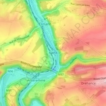
Name: Neffe topographic map, elevation, terrain.

Location: Neffe, Dinant, Namur, Wallonia, 5500, Belgium (50.22827 4.89788 50.26827 4.93788)

Average elevation: 604 ft

Minimum elevation: 246 ft

Maximum elevation: 938 ft

Other topographic maps

Click on a map to view its topography, its elevation and its terrain.

Dréhance

Belgium > Namur > Dinant > Dinant

Average elevation: 643 ft

Rocher du Pendu

Belgium > Namur > Dinant > Dinant

Average elevation: 554 ft

Gear up for your next adventure:

🧭Compass with Lanyard - Easy‑carry compass for navigation
😴Insulated Sleeping Pads - Compact and warm pads for high-elevation camping
🩳Quick‑Dry Hiking Shorts - Comfortable and quick‑dry shorts for summer hiking
🧭Map Reading Tools - Tools and kits for map navigation
🪶Trail Camera - Capture wildlife on your hikes

As an Amazon Associate, this site earns from qualifying purchases at no extra cost to you.