
Sant'Eustacchio topographic map
Interactive map
Click on the map to display elevation.
About this map
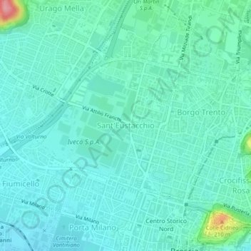
Name: Sant'Eustacchio topographic map, elevation, terrain.
Location: Sant'Eustacchio, Zona Nord, Brescia, Lombardia, Italia (45.54531 10.19596 45.56133 10.22165)
Average elevation: 525 ft
Minimum elevation: 459 ft
Maximum elevation: 850 ft
Other topographic maps
Click on a map to view its topography, its elevation and its terrain.