
Thank you for supporting this site ❤️
Make a donation
Make a donation
Gear up for your next adventure:
As an Amazon Associate, this site earns from qualifying purchases at no extra cost to you.
双庙 topographic map
Click on the map to display elevation.
Thank you for supporting this site ❤️
Make a donation
Make a donation
Gear up for your next adventure:
As an Amazon Associate, this site earns from qualifying purchases at no extra cost to you.
About this map
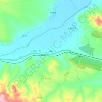
Name: 双庙 topographic map, elevation, terrain.
Location: 双庙, 当铺地满族乡, 松山区, 赤峰市, 内蒙古自治区, 024000, 中国 (42.31802 118.73212 42.35802 118.77212)
Average elevation: 2,221 ft
Minimum elevation: 2,014 ft
Maximum elevation: 2,759 ft
Thank you for supporting this site ❤️
Make a donation
Make a donation
Gear up for your next adventure:
As an Amazon Associate, this site earns from qualifying purchases at no extra cost to you.