
Wüste topographic map
Interactive map
Click on the map to display elevation.
About this map
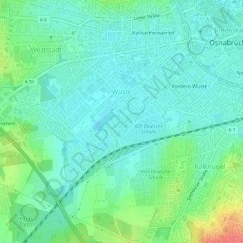
Name: Wüste topographic map, elevation, terrain.
Location: Wüste, Osnabrück, Niedersachsen, 49080, Deutschland (52.25416 8.00706 52.27214 8.05080)
Average elevation: 253 ft
Minimum elevation: 203 ft
Maximum elevation: 390 ft
Other topographic maps
Click on a map to view its topography, its elevation and its terrain.
Osnabrück
Deutschland > Niedersachsen > Osnabrück > Osnabrück
Osnabrück, Niedersachsen, 49074, Deutschland
Average elevation: 305 ft