Geolocate

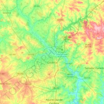
Goiânia topographic map

Click on the map to display elevation.

Goiânia

The "cerrado" landscape is characterized by extensive savanna formations crossed by gallery forests and stream valleys and includes various types of vegetation. Humid fields and "buriti" palm paths are found where the water table is near the surface. Alpine pastures occur at higher altitudes and mesophytic forests on more fertile soils.

Wikipedia (CC-BY-SA 3.0)

About this map

Name: Goiânia topographic map, elevation, terrain.

Location: Goiânia, Região Geográfica Imediata de Goiânia, Região Geográfica Intermediária de Goiânia, Goiás, Central-West Region, Brazil (-16.83188 -49.44695 -16.45421 -49.07800)

Average elevation: 2,608 ft

Minimum elevation: 2,175 ft

Maximum elevation: 3,409 ft

Gear up for your next adventure:

💧Water Purification System - Clean water on the trail with reliable purifiers
🥾Hiking Shoes - Durable and comfortable shoes for trail hiking
❄️Traction Cleats - Prevent slips on icy trails during winter hikes
🌧️Backpack Rain Cover - Keep gear dry in wet weather
🧦Merino Wool Socks - Moisture-wicking, blister-preventing socks for long treks

As an Amazon Associate, this site earns from qualifying purchases at no extra cost to you.