
Thank you for supporting this site ❤️
Make a donation
Make a donation
Gear up for your next adventure:
As an Amazon Associate, this site earns from qualifying purchases at no extra cost to you.
Skellefteå topographic map
Click on the map to display elevation.
Thank you for supporting this site ❤️
Make a donation
Make a donation
Gear up for your next adventure:
As an Amazon Associate, this site earns from qualifying purchases at no extra cost to you.
About this map
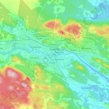
Name: Skellefteå topographic map, elevation, terrain.
Location: Skellefteå, Skellefteå kommun, Västerbotten County, Sweden (64.71455 20.87541 64.77977 21.10801)
Average elevation: 161 ft
Minimum elevation: -16 ft
Maximum elevation: 561 ft
Thank you for supporting this site ❤️
Make a donation
Make a donation
Gear up for your next adventure:
As an Amazon Associate, this site earns from qualifying purchases at no extra cost to you.