Geolocate

Leeuwarden topographic map

Click on the map to display elevation.

About this map

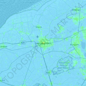
Name: Leeuwarden topographic map, elevation, terrain.

Location: Leeuwarden, Frisia, Netherlands, 8911BR, Netherlands (53.04059 5.63185 53.36059 5.95185)

Average elevation: 0 ft

Minimum elevation: -16 ft

Maximum elevation: 36 ft

Gear up for your next adventure:

🕶️Glacier Sunglasses - Side shields to protect eyes from high-altitude snow glare
🥾Hiking Shoes - Durable and comfortable shoes for trail hiking
🧭Outdoor Navigation Book - Learn advanced navigation skills
🔌USB Car Charger - Car charger for on‑the‑go power needs
Camping Coffee Makers - Enjoy premium coffee at the summit or campsite

As an Amazon Associate, this site earns from qualifying purchases at no extra cost to you.