
Make a donation
Gear up for your next adventure:
As an Amazon Associate, this site earns from qualifying purchases at no extra cost to you.
Gandia topographic map
Click on the map to display elevation.
Make a donation
Gear up for your next adventure:
As an Amazon Associate, this site earns from qualifying purchases at no extra cost to you.
About this map
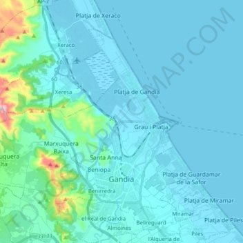
Name: Gandia topographic map, elevation, terrain.
Location: Gandia, la Safor, Valencia, Valencian Community, Spain (38.94981 -0.29715 39.04128 -0.14424)
Average elevation: 164 ft
Minimum elevation: -7 ft
Maximum elevation: 1,837 ft
Make a donation
Gear up for your next adventure:
As an Amazon Associate, this site earns from qualifying purchases at no extra cost to you.
Other topographic maps
Click on a map to view its topography, its elevation and its terrain.
Castillo de Peñiscola
Spain > Valencian Community > Castelló / Castellón > Peníscola / Peñíscola
The castle is situated on a crag overlooking the Mediterranean Sea, at an altitude of 64 metres (210 ft) above mean sea level.
Average elevation: 16 ft