
Town of Winneconne topographic map
Interactive map
Click on the map to display elevation.
About this map
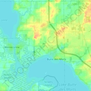
Name: Town of Winneconne topographic map, elevation, terrain.
Average elevation: 771 ft
Minimum elevation: 738 ft
Maximum elevation: 853 ft
Other topographic maps
Click on a map to view its topography, its elevation and its terrain.
Neenah
United States > Wisconsin > Winnebago County
Neenah, Winnebago County, Wisconsin, 54956, United States
Average elevation: 755 ft
Town of Nekimi
United States > Wisconsin > Winnebago County
Town of Nekimi, Winnebago County, Wisconsin, United States
Average elevation: 850 ft
Omro
United States > Wisconsin > Winnebago County > Omro
Omro, Winnebago County, Wisconsin, 54963, United States
Average elevation: 771 ft
Piacenza
United States > Wisconsin > Winnebago County > Piacenza
Piacenza, Town of Winneconne, Winnebago County, Wisconsin, 54986, United States
Average elevation: 758 ft
Oshkosh
United States > Wisconsin > Winnebago County
Oshkosh, Winnebago County, Wisconsin, United States
Average elevation: 771 ft