
Bir El Ater topographic map
Interactive map
Click on the map to display elevation.
About this map
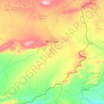
Name: Bir El Ater topographic map, elevation, terrain.
Location: Bir El Ater, daïra Bir Elater, Tébessa, Algérie (34.40517 7.73286 34.96593 8.30104)
Average elevation: 2,428 ft
Minimum elevation: 1,079 ft
Maximum elevation: 4,862 ft
Other topographic maps
Click on a map to view its topography, its elevation and its terrain.
Djebel Onk
Algérie > Tébessa > daïra Bir Elater > Bir El Ater
Djebel Onk, Bir El Ater, daïra Bir Elater, Tébessa, Algérie
Average elevation: 3,189 ft