
Kent topographic map
Interactive map
Click on the map to display elevation.
About this map
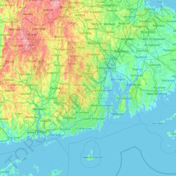
Name: Kent topographic map, elevation, terrain.
Location: Kent, Rhode Island, Estados Unidos da América (41.03229 -72.24276 42.31229 -70.96276)
Average elevation: 223 ft
Minimum elevation: -26 ft
Maximum elevation: 1,355 ft
Other topographic maps
Click on a map to view its topography, its elevation and its terrain.
Warwick
Estados Unidos da América > Rhode Island > Kent County
Warwick, Kent County, Rhode Island, Estados Unidos da América
Average elevation: 112 ft
Providence
Estados Unidos da América > Rhode Island
Providence, Rhode Island, 02828, Estados Unidos da América
Average elevation: 285 ft
Dutch Island
Estados Unidos da América > Rhode Island > Jamestown
Dutch Island, Jamestown, Newport, Rhode Island, Estados Unidos da América
Average elevation: 3 ft
River Ledge
Estados Unidos da América > Rhode Island > Narragansett
River Ledge, Thule Cove Road, Narragansett, Newport, Rhode Island, 02880, Estados Unidos da América
Average elevation: 3 ft
Prudence Island
Estados Unidos da América > Rhode Island > Portsmouth
Prudence Island, Portsmouth, Bristol, Rhode Island, Estados Unidos da América
Average elevation: 20 ft