
Make a donation
Gear up for your next adventure:
As an Amazon Associate, this site earns from qualifying purchases at no extra cost to you.
Coaldale topographic map
Click on the map to display elevation.
Make a donation
Gear up for your next adventure:
As an Amazon Associate, this site earns from qualifying purchases at no extra cost to you.
Coaldale
Coaldale is located at 40°49′20″N 75°54′36″W / 40.82222°N 75.91000°W / 40.82222; -75.91000 (40.822234, -75.910115), which is (technically) one mile southwest of Lansford as both municipalities lie along the border of Carbon and Schuylkill Counties. It is also five miles northeast of Tamaqua, 27 miles northwest of Allentown, and nine miles south of Hazleton. It is located on the northwestern fringe of the Lehigh Valley and just two ridgelines away from the nearby Poconos, and drains to the Delaware River by way of Panther Creek, the Little Schuylkill River, and the Schuylkill River. Coaldale sits atop one of the richest coal seams in the eastern end of the southern Coal Region, which is still being exploited by a successor company of the LC&N (called the Old Company in the valley), the Lehigh Coal and Navigation Company (or the New Company). Coaldale's elevation is 1050 feet above sea level. According to the United States Census Bureau, the borough has a total area of 2.2 square miles (5.7 km2), all land.
Make a donation
Gear up for your next adventure:
As an Amazon Associate, this site earns from qualifying purchases at no extra cost to you.
About this map
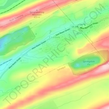
Name: Coaldale topographic map, elevation, terrain.
Location: Coaldale, Schuylkill County, Pennsylvania, United States (40.80536 -75.93620 40.83374 -75.89154)
Average elevation: 1,181 ft
Minimum elevation: 827 ft
Maximum elevation: 1,572 ft
Schuylkill County trails, hiking, mountain biking, running and outdoor activities
Make a donation
Gear up for your next adventure:
As an Amazon Associate, this site earns from qualifying purchases at no extra cost to you.
Other topographic maps
Click on a map to view its topography, its elevation and its terrain.
Zion Grove
United States > Pennsylvania > Schuylkill County > North Union Township
Average elevation: 1,060 ft
New Mines
United States > Pennsylvania > Schuylkill County > Reilly Township
Average elevation: 1,109 ft
Bear Ridge
United States > Pennsylvania > Schuylkill County > West Mahanoy Township
Average elevation: 1,276 ft
Rough and Ready
United States > Pennsylvania > Schuylkill County > Upper Mahantango Township
Average elevation: 768 ft
Make a donation
Gear up for your next adventure:
As an Amazon Associate, this site earns from qualifying purchases at no extra cost to you.
Jefferson
United States > Pennsylvania > Schuylkill County > South Manheim Township
Average elevation: 705 ft
Blue Mountain
United States > Pennsylvania > Schuylkill County > West Penn Township
The ridge of Blue Mountain runs for 150 miles (240 km) through Pennsylvania, reaching an elevation of 2,270 feet (690 m) above sea level just north of the Pennsylvania Turnpike, near the borough of Newburg. Most of the ridgecrest, however, only reaches between 1,400 and 1,700 feet (430 and 520 m) in elevation.…
Average elevation: 823 ft
Helfenstein
United States > Pennsylvania > Schuylkill County > Butler Township
Average elevation: 1,273 ft
Make a donation
Gear up for your next adventure:
As an Amazon Associate, this site earns from qualifying purchases at no extra cost to you.
Newton Junction
United States > Pennsylvania > Schuylkill County > Mahanoy Township
Average elevation: 1,506 ft
Lincoln
United States > Pennsylvania > Schuylkill County > Tremont Township > Lincoln
Average elevation: 1,335 ft
Lower Brownsville
United States > Pennsylvania > Schuylkill County > West Mahanoy Township
Average elevation: 1,394 ft