
Ain Kermat topographic map
Interactive map
Click on the map to display elevation.
About this map
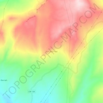
Name: Ain Kermat topographic map, elevation, terrain.
Location: Ain Kermat, Oued Athmania, Daïra Chelghoum Laïd, Mila, Algérie (36.30311 6.33325 36.34311 6.37325)
Average elevation: 3,238 ft
Minimum elevation: 2,664 ft
Maximum elevation: 3,799 ft
Other topographic maps
Click on a map to view its topography, its elevation and its terrain.
Aïn Foua
Algérie > Mila > Daïra Chelghoum Laïd > Oued Athmania
Aïn Foua, Oued Athmania, Daïra Chelghoum Laïd, Mila, Algérie
Average elevation: 3,360 ft
Ain Salah
Algérie > Mila > Daïra Chelghoum Laïd > Oued Athmania
Ain Salah, Route Oued Othmania, Oued Athmania, Daïra Chelghoum Laïd, Mila, Algérie
Average elevation: 2,766 ft