
Franconia topographic map
Interactive map
Click on the map to display elevation.
About this map
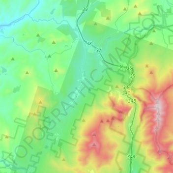
Name: Franconia topographic map, elevation, terrain.
Average elevation: 1,831 ft
Minimum elevation: 597 ft
Maximum elevation: 5,190 ft
Other topographic maps
Click on a map to view its topography, its elevation and its terrain.
Lyman
United States > New Hampshire > Grafton County
Lyman, Grafton County, New Hampshire, United States
Average elevation: 1,138 ft
Warren
United States > New Hampshire > Grafton County
Warren, Grafton County, New Hampshire, United States
Average elevation: 1,558 ft
Bonsai
United States > New Hampshire > Grafton County > Rumney
Bonsai, Rumney, Grafton County, New Hampshire, 03266, United States
Average elevation: 807 ft
Waterville Valley
United States > New Hampshire > Grafton County
Waterville Valley, Grafton County, New Hampshire, 03215, United States
Average elevation: 2,129 ft
Groton
United States > New Hampshire > Grafton County
Groton, Grafton County, New Hampshire, United States
Average elevation: 1,201 ft
Plymouth
United States > New Hampshire > Grafton County
Plymouth, Grafton County, New Hampshire, 03264, United States
Average elevation: 866 ft
Wentworth
United States > New Hampshire > Grafton County
Wentworth, Grafton County, New Hampshire, 03282, United States
Average elevation: 1,385 ft
Bath
United States > New Hampshire > Grafton County
Bath, Grafton County, New Hampshire, 03740, United States
Average elevation: 948 ft
North Haverhill
United States > New Hampshire > Grafton County > Haverhill
North Haverhill, Haverhill, Grafton County, New Hampshire, 03774, United States
Average elevation: 489 ft
Stinson Lake
United States > New Hampshire > Grafton County > Rumney > Stinson Lake
Stinson Lake, Rumney, Grafton County, New Hampshire, United States
Average elevation: 1,509 ft
Echo Lake
United States > New Hampshire > Grafton County > Franconia
Echo Lake, Franconia, Grafton County, New Hampshire, United States
Average elevation: 2,274 ft
Lebanon
United States > New Hampshire > Grafton County
Lebanon, Grafton County, New Hampshire, United States
Average elevation: 899 ft
Mount Kineo, East Peak
United States > New Hampshire > Grafton County > Ellsworth
Mount Kineo, East Peak, Ellsworth, Grafton County, New Hampshire, United States
Average elevation: 2,329 ft
Etna
United States > New Hampshire > Grafton County > Hanover
Etna, Hanover, Grafton County, New Hampshire, 03750, United States
Average elevation: 971 ft
Holderness
United States > New Hampshire > Grafton County
Holderness, Grafton County, New Hampshire, 03245, United States
Average elevation: 827 ft
Bristol
United States > New Hampshire > Grafton County
Bristol, Grafton County, New Hampshire, 03222, United States
Average elevation: 833 ft
Enfield
United States > New Hampshire > Grafton County
Enfield, Grafton County, New Hampshire, United States
Average elevation: 1,201 ft
Sugar Hill
United States > New Hampshire > Grafton County > Sugar Hill
Sugar Hill, Grafton County, New Hampshire, 03586, United States
Average elevation: 1,220 ft
Mount Agassiz
United States > New Hampshire > Grafton County > Bethlehem
Mount Agassiz, Bethlehem, Grafton County, New Hampshire, 03574, United States
Average elevation: 1,831 ft
Littleton
United States > New Hampshire > Grafton County > Littleton
Littleton, Grafton County, New Hampshire, United States
Average elevation: 1,181 ft
North Littleton
United States > New Hampshire > Grafton County > Littleton > North Littleton
North Littleton, Littleton, Grafton County, New Hampshire, United States
Average elevation: 1,093 ft
West Lebanon
United States > New Hampshire > Grafton County > Lebanon > West Lebanon
West Lebanon, Lebanon, Grafton County, New Hampshire, 03784, United States
Average elevation: 541 ft
Lebanon
United States > New Hampshire > Grafton County > Lebanon
Lebanon, Grafton County, New Hampshire, 03766-1355, United States
Average elevation: 1,033 ft
LeBruns Mobile Home Park
United States > New Hampshire > Grafton County > Lebanon > LeBruns Mobile Home Park
LeBruns Mobile Home Park, Lebanon, Grafton County, New Hampshire, United States
Average elevation: 1,070 ft
Thornton
United States > New Hampshire > Grafton County
Thornton, Grafton County, New Hampshire, United States
Average elevation: 1,555 ft
Bethlehem
United States > New Hampshire > Grafton County > Bethlehem
Bethlehem, Grafton County, New Hampshire, 03574, United States
Average elevation: 1,732 ft
Easton
United States > New Hampshire > Grafton County
Easton, Grafton County, New Hampshire, United States
Average elevation: 1,923 ft
Lincoln
United States > New Hampshire > Grafton County
Lincoln, Grafton County, New Hampshire, 03251, United States
Average elevation: 2,221 ft
Lyme
United States > New Hampshire > Grafton County
Lyme, Grafton County, New Hampshire, United States
Average elevation: 974 ft
Orford
United States > New Hampshire > Grafton County
Orford, Grafton County, New Hampshire, United States
Average elevation: 984 ft