Geolocate

Settignano topographic map

Click on the map to display elevation.

About this map

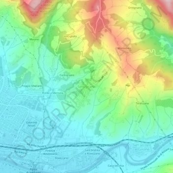
Name: Settignano topographic map, elevation, terrain.

Location: Settignano, Florence, Tuscany, 50135, Italy (43.76299 11.30082 43.80299 11.34082)

Average elevation: 518 ft

Minimum elevation: 151 ft

Maximum elevation: 1,401 ft

Gear up for your next adventure:

🧷Carabiner Set - Durable clips for gear attachment
❄️Traction Cleats - Prevent slips on icy trails during winter hikes
GPS Sports Watch - GPS watch for running, hiking and training
🎒Waterproof Dry Bags - Keep your electronics and maps dry inside your pack
🌡️Portable Weather Meter - Track weather conditions on the trail

As an Amazon Associate, this site earns from qualifying purchases at no extra cost to you.