
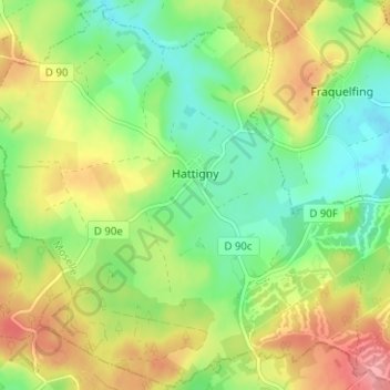
Hattingen topographic map
Interactive map
Click on the map to display elevation.
About this map
Name: Hattingen topographic map, elevation, terrain.
Average elevation: 1,066 ft
Minimum elevation: 932 ft
Maximum elevation: 1,247 ft
Other topographic maps
Click on a map to view its topography, its elevation and its terrain.
Kleinrosseln
Frankreich > Grand Est > Mosel
Kleinrosseln, Forbach-Bolchen, Mosel, Grand Est, Metropolitanes Frankreich, 57540, Frankreich
Average elevation: 801 ft
Sankt Hubert
Frankreich > Grand Est > Mosel
Sankt Hubert, Metz, Mosel, Grand Est, Metropolitanes Frankreich, 57640, Frankreich
Average elevation: 856 ft
Alberschweiler
Frankreich > Grand Est > Mosel
Alberschweiler, Sarrebourg-Château-Salins, Mosel, Grand Est, Metropolitanes Frankreich, 57560, Frankreich
Average elevation: 1,385 ft
Tressingen
Frankreich > Grand Est > Mosel
Tressingen, Diedenhofen, Mosel, Grand Est, Metropolitanes Frankreich, 57710, Frankreich
Average elevation: 1,178 ft
Willingen
Frankreich > Grand Est > Mosel
Willingen, Forbach-Bolchen, Mosel, Grand Est, Metropolitanes Frankreich, 57550, Frankreich
Average elevation: 942 ft
Mondorf
Frankreich > Grand Est > Mosel
Mondorf, Diedenhofen, Mosel, Grand Est, Metropolitanes Frankreich, 57570, Frankreich
Average elevation: 768 ft
Burscheid
Frankreich > Grand Est > Mosel
Burscheid, Sarrebourg-Château-Salins, Mosel, Grand Est, Metropolitanes Frankreich, 57370, Frankreich
Average elevation: 978 ft
Metz
Frankreich > Grand Est > Mosel
Metz, Mosel, Grand Est, Metropolitanes Frankreich, Frankreich
Average elevation: 643 ft