
Thank you for supporting this site ❤️
Make a donation
Make a donation
Gear up for your next adventure:
As an Amazon Associate, this site earns from qualifying purchases at no extra cost to you.
Galimuyod topographic map
Click on the map to display elevation.
Thank you for supporting this site ❤️
Make a donation
Make a donation
Gear up for your next adventure:
As an Amazon Associate, this site earns from qualifying purchases at no extra cost to you.
About this map
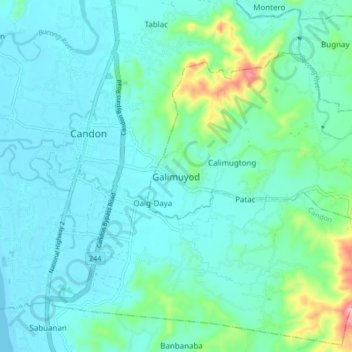
Name: Galimuyod topographic map, elevation, terrain.
Location: Galimuyod, Ilocos Sur, Ilocos Region, 2710, Philippines (17.14313 120.42922 17.22313 120.50922)
Average elevation: 118 ft
Minimum elevation: 0 ft
Maximum elevation: 709 ft
Thank you for supporting this site ❤️
Make a donation
Make a donation
Gear up for your next adventure:
As an Amazon Associate, this site earns from qualifying purchases at no extra cost to you.