
Appenzell topographic map
Interactive map
Click on the map to display elevation.
About this map
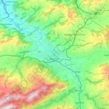
Name: Appenzell topographic map, elevation, terrain.
Location: Appenzell, Appenzell Rhodes-Intérieures, 9050, Suisse (47.30427 9.37190 47.36127 9.47923)
Average elevation: 3,084 ft
Minimum elevation: 2,244 ft
Maximum elevation: 4,469 ft
Other topographic maps
Click on a map to view its topography, its elevation and its terrain.
Ebenalp
Suisse > Appenzell Rhodes-Intérieures > Schwende-Rüte
Ebenalp, Schwende, Schwende-Rüte, Appenzell Rhodes-Intérieures, 9057, Suisse
Average elevation: 4,045 ft
Seealpsee
Suisse > Appenzell Rhodes-Intérieures > Schwende-Rüte
Seealpsee, Schwende, Schwende-Rüte, Appenzell Rhodes-Intérieures, 9057, Suisse
Average elevation: 4,895 ft
Oberegg
Suisse > Appenzell Rhodes-Intérieures
Oberegg, Appenzell Rhodes-Intérieures, 9413, Suisse
Average elevation: 2,556 ft