
Stony Creek topographic map
Interactive map
Click on the map to display elevation.
About this map
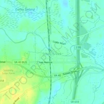
Name: Stony Creek topographic map, elevation, terrain.
Location: Stony Creek, Sussex County, Virginia, United States (36.94030 -77.40639 36.95648 -77.39134)
Average elevation: 79 ft
Minimum elevation: 52 ft
Maximum elevation: 128 ft
Other topographic maps
Click on a map to view its topography, its elevation and its terrain.
Wakefield
United States > Virginia > Sussex County
Wakefield, Sussex County, Virginia, United States
Average elevation: 102 ft
Waverly
United States > Virginia > Sussex County > Waverly
Waverly, Sussex County, Virginia, United States
Average elevation: 108 ft