
Auerbach/Vogtland topographic map
Interactive map
Click on the map to display elevation.
About this map
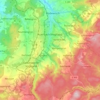
Name: Auerbach/Vogtland topographic map, elevation, terrain.
Location: Auerbach/Vogtland, Vogtlandkreis, Saxony, 08209, Germany (50.44111 12.33176 50.54383 12.49567)
Average elevation: 1,923 ft
Minimum elevation: 1,339 ft
Maximum elevation: 2,589 ft
Other topographic maps
Click on a map to view its topography, its elevation and its terrain.
Tauschwitz
Germany > Saxony > Vogtlandkreis > Plauen > Stöckigt
Tauschwitz, Stöckigt, Plauen, Vogtlandkreis, Saxony, 08527, Germany
Average elevation: 1,375 ft