
Make a donation
Gear up for your next adventure:
As an Amazon Associate, this site earns from qualifying purchases at no extra cost to you.
Les Ulis topographic map
Click on the map to display elevation.
Make a donation
Gear up for your next adventure:
As an Amazon Associate, this site earns from qualifying purchases at no extra cost to you.
Les Ulis
The source of the minor river Rouillon (river) is in the neighbouring town of Villejust, close to the communal border. The lowest point of the town, at the point where it meets Bures-sur-Yvette, is at an altitude of 87m. Most of the town is situated at an average altitude of over 150m. Its highest point is at 170m. The land on which it is built consists of clay, sand and millstone.
Make a donation
Gear up for your next adventure:
As an Amazon Associate, this site earns from qualifying purchases at no extra cost to you.
About this map
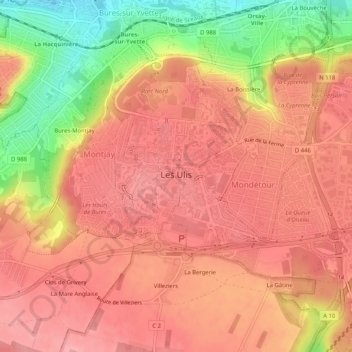
Name: Les Ulis topographic map, elevation, terrain.
Average elevation: 453 ft
Minimum elevation: 197 ft
Maximum elevation: 571 ft
Make a donation
Gear up for your next adventure:
As an Amazon Associate, this site earns from qualifying purchases at no extra cost to you.
Other topographic maps
Click on a map to view its topography, its elevation and its terrain.
Paris Basin
France > Ile-de-France > Essonne > Bièvres
The landscape is one of very broad valleys (flood plains), modest watershed hills and well-drained plateaux of comparatively little altitude. In the south-east and east the plain of Champagne and the Seuil de Bourgogne (Threshold of Burgundy) differential erosion of the strata has left low scarps with the dip…
Average elevation: 413 ft