
Handschuhspitze P. 2319 topographic map
Interactive map
Click on the map to display elevation.
About this map
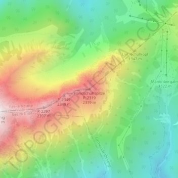
Name: Handschuhspitze P. 2319 topographic map, elevation, terrain.
Average elevation: 5,958 ft
Minimum elevation: 4,498 ft
Maximum elevation: 8,107 ft
Other topographic maps
Click on a map to view its topography, its elevation and its terrain.
Grubigstein
Österreich > Tirol > Bezirk Reutte > Gemeinde Biberwier
Grubigstein, Gemeinde Biberwier, Bezirk Reutte, Tirol, 6631, Österreich
Average elevation: 5,666 ft