
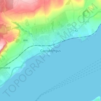
Carrickfergus topographic map
Interactive map
Click on the map to display elevation.
About this map
Name: Carrickfergus topographic map, elevation, terrain.
Average elevation: 161 ft
Minimum elevation: 0 ft
Maximum elevation: 922 ft
Other topographic maps
Click on a map to view its topography, its elevation and its terrain.
Ahoghill
United Kingdom > Northern Ireland > County Antrim
Ahoghill, County Antrim, Ulster, Northern Ireland, BT42 1JZ, United Kingdom
Average elevation: 276 ft
Portrush
United Kingdom > Northern Ireland > County Antrim
Portrush, County Antrim, Ulster, Northern Ireland, BT56 8BN, United Kingdom
Average elevation: 75 ft
Ballymena
United Kingdom > Northern Ireland > County Antrim
Ballymena, County Antrim, Northern Ireland, BT43 6DT, United Kingdom
Average elevation: 243 ft
Larne
United Kingdom > Northern Ireland > County Antrim
Larne, County Antrim, Northern Ireland, BT40 1JS, United Kingdom
Average elevation: 177 ft
Belfast
United Kingdom > Northern Ireland > County Antrim
Belfast, County Antrim, Ulster, Northern Ireland, BT1 5GS, United Kingdom
Average elevation: 285 ft
Antrim
United Kingdom > Northern Ireland > County Antrim
Antrim, County Antrim, Northern Ireland, BT41 4AR, United Kingdom
Average elevation: 164 ft