Geolocate

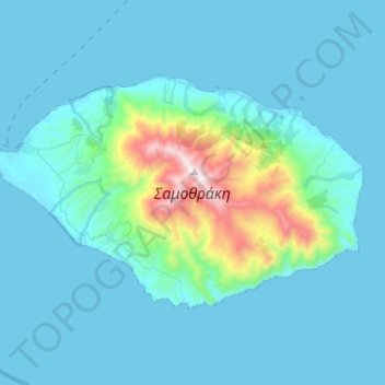
Samothraki topographic map

Click on the map to display elevation.

Samothraki

Samothraki has a hot-summer Mediterranean climate. Winters are cool and rainy with occasional heavy snowstorms, especially at higher elevations.

Wikipedia (CC-BY-SA 3.0)

About this map

Name: Samothraki topographic map, elevation, terrain.

Location: Samothraki, Evros Regional Unit, Eastern Macedonia and Thrace, Macedonia and Thrace, 680 02, Greece (40.39222 25.44339 40.51030 25.69964)

Average elevation: 558 ft

Minimum elevation: 0 ft

Maximum elevation: 5,243 ft

Other topographic maps

Click on a map to view its topography, its elevation and its terrain.

Gear up for your next adventure:

🧯Emergency Survival Kit - All‑in‑one survival essentials for the backcountry
🛶Inflatable Kayak - Portable kayak for rivers, lakes, and expeditions
🖼️Topo Map Wall Art - Decorative topographic prints of famous peaks and regions
🌄Hiking Binoculars - Compact binoculars for scenic views and trail spotting
🦟Ultrasonic Repellers - Create a bug-free zone at your camp or rest stop

As an Amazon Associate, this site earns from qualifying purchases at no extra cost to you.