
Somber topographic map
Interactive map
Click on the map to display elevation.
About this map
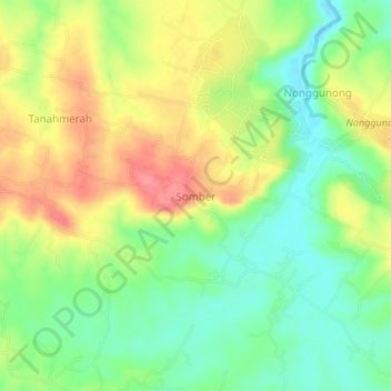
Name: Somber topographic map, elevation, terrain.
Location: Somber, East Java, Indonesia (-7.11355 114.30856 -7.07355 114.34856)
Average elevation: 135 ft
Minimum elevation: 16 ft
Maximum elevation: 276 ft
Other topographic maps
Click on a map to view its topography, its elevation and its terrain.
Gunung Malang
Gunung Malang, Situbondo, East Java, Indonesia
Average elevation: 971 ft
Gunung Lawu
Indonesia > East Java > Madiun
Gunung Lawu, Madiun, East Java, Indonesia
Average elevation: 9,452 ft