
Sidi Moussa topographic map
Interactive map
Click on the map to display elevation.
About this map
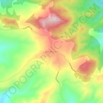
Name: Sidi Moussa topographic map, elevation, terrain.
Location: Sidi Moussa, Dahra, Daïra Taougrite, Chlef, Algérie (36.23055 0.73624 36.27055 0.77624)
Average elevation: 1,844 ft
Minimum elevation: 1,194 ft
Maximum elevation: 2,536 ft
Other topographic maps
Click on a map to view its topography, its elevation and its terrain.
El Ataitia
Algérie > Chlef > Daïra Taougrite > Dahra
El Ataitia, Dahra, Daïra Taougrite, Chlef, 02036, Algérie
Average elevation: 1,509 ft