
Bas-Rhin topographic map
Interactive map
Click on the map to display elevation.
About this map
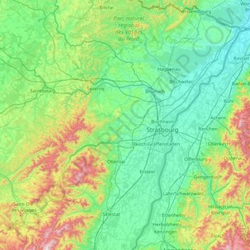
Name: Bas-Rhin topographic map, elevation, terrain.
Location: Bas-Rhin, Grand Est, Metropolitan France, France (48.12043 6.94063 49.07779 8.23285)
Average elevation: 1,033 ft
Minimum elevation: 341 ft
Maximum elevation: 4,180 ft
Bas-Rhin (French pronunciation: [bɑ.ʁɛ̃]; Alsatian: Unterelsàss, ‘s Unterlànd or ‘s Ingerlànd; traditional German: Niederrhein; English: Lower Rhine) is a department in Alsace which is a part of the Grand Est super-region of France. The name means 'Lower Rhine', referring to its lower altitude among the two French Rhine departments: it is downstream of the Haut-Rhin (Upper Rhine) department. Note that both belong to the European Upper Rhine region. It is, with the Haut-Rhin (Upper Rhine), one of the two departments of the traditional Alsace region which until 1871, also included the area now known as the Territoire de Belfort. The more populous and densely populated of the pair, it had 1,140,057 inhabitants in 2019. The prefecture is based in Strasbourg. The INSEE and Post Code is 67.
Other topographic maps
Click on a map to view its topography, its elevation and its terrain.
Olizy-Primat
Olizy-Primat, Vouziers, Ardennes, Grand Est, Metropolitan France, 08250, France
Average elevation: 505 ft
Les Côtes Jopin
France > Grand Est > Marne > Changy
Les Côtes Jopin, Changy, Vitry-le-François, Marne, Grand Est, Metropolitan France, 51300, France
Average elevation: 433 ft
68116
France > Grand Est > Haut-Rhin > Guewenheim
68116, Guewenheim, Thann-Guebwiller, Haut-Rhin, Grand Est, Metropolitan France, France
Average elevation: 1,119 ft
Château-Salins
Château-Salins, Sarrebourg-Château-Salins, Moselle, Grand Est, Metropolitan France, 57170, France
Average elevation: 794 ft
Cléry-le-Grand
Cléry-le-Grand, Verdun, Meuse, Grand Est, Metropolitan France, 55110, France
Average elevation: 728 ft
Vaux-Champagne
Vaux-Champagne, Vouziers, Ardennes, Grand Est, Metropolitan France, 08130, France
Average elevation: 377 ft
Ville-Houdlémont
France > Grand Est > Meurthe-et-Moselle
Ville-Houdlémont, Val-de-Briey, Meurthe-et-Moselle, Grand Est, Metropolitan France, 54730, France
Average elevation: 958 ft
Nancy
France > Grand Est > Meurthe-et-Moselle
Nancy, Meurthe-et-Moselle, Grand Est, Metropolitan France, France
Average elevation: 755 ft
Chennevières
France > Grand Est > Meuse > Chanteraine
Chennevières, Chanteraine, Bar-le-Duc, Meuse, Grand Est, Metropolitan France, 55500, France
Average elevation: 1,099 ft
Praire
France > Grand Est > Meuse > Sorcy-Saint-Martin
Praire, Sorcy-Saint-Martin, Commercy, Meuse, Grand Est, Metropolitan France, 55190, France
Average elevation: 827 ft
Fort St Michel
France > Grand Est > Meuse > Belleville-sur-Meuse
Fort St Michel, Chemin strategique n° 2, Quartier Bayard, Belleville-sur-Meuse, Verdun, Meuse, Grand Est, Metropolitan France, 55430, France
Average elevation: 896 ft
Berrwiller
France > Grand Est > Haut-Rhin
Berrwiller, Mulhouse, Haut-Rhin, Grand Est, Metropolitan France, 68500, France
Average elevation: 889 ft
Dogneville
Dogneville, Épinal, Vosges, Grand Est, Metropolitan France, 88000, France
Average elevation: 1,106 ft
Mansard
France > Grand Est > Meuse > Dombasle-en-Argonne
Mansard, Dombasle-en-Argonne, Verdun, Meuse, Grand Est, Metropolitan France, 55120, France
Average elevation: 935 ft
Eschwiller
Eschwiller, Saverne, Bas-Rhin, Grand Est, Metropolitan France, 67320, France
Average elevation: 988 ft
La Puce
France > Grand Est > Meurthe-et-Moselle > Boismont
La Puce, Boismont, Val-de-Briey, Meurthe-et-Moselle, Grand Est, Metropolitan France, 54620, France
Average elevation: 938 ft
Dommartin-lès-Toul
France > Grand Est > Meurthe-et-Moselle
Dommartin-lès-Toul, Toul, Meurthe-et-Moselle, Grand Est, Metropolitan France, 54200, France
Average elevation: 748 ft
Ath
France > Grand Est > Bas-Rhin > Diemeringen
Ath, Diemeringen, Saverne, Bas-Rhin, Grand Est, Metropolitan France, 67430, France
Average elevation: 837 ft
Mourmelon-le-Grand
Mourmelon-le-Grand, Châlons-en-Champagne, Marne, Grand Est, Metropolitan France, 51400, France
Average elevation: 407 ft
Saint-Memmie
Saint-Memmie, Châlons-en-Champagne, Marne, Grand Est, Metropolitan France, 51470, France
Average elevation: 322 ft
Croix Allart
France > Grand Est > Marne > Bétheny
Croix Allart, Bétheny, Reims, Marne, Grand Est, Metropolitan France, 51450, France
Average elevation: 308 ft
Saint-Brice-Courcelles
Saint-Brice-Courcelles, Reims, Marne, Grand Est, Metropolitan France, 51370, France
Average elevation: 259 ft
Montmirail
Montmirail, Épernay, Marne, Grand Est, Metropolitan France, 51210, France
Average elevation: 617 ft
Nogent
France > Grand Est > Haute-Marne
Nogent, Chaumont, Haute-Marne, Grand Est, Metropolitan France, 52800, France
Average elevation: 1,309 ft
Witry-lès-Reims
Witry-lès-Reims, Reims, Marne, Grand Est, Metropolitan France, 51420, France
Average elevation: 390 ft
Vitry-le-François
Vitry-le-François, Marne, Grand Est, Metropolitan France, 51300, France
Average elevation: 331 ft
Aÿ-Champagne
Aÿ-Champagne, Épernay, Marne, Grand Est, Metropolitan France, France
Average elevation: 417 ft
Cormontreuil
Cormontreuil, Reims, Marne, Grand Est, Metropolitan France, 51350, France
Average elevation: 322 ft
Villers-Semeuse
Villers-Semeuse, Charleville-Mézières, Ardennes, Grand Est, Metropolitan France, 08000, France
Average elevation: 522 ft
Vrigne-aux-Bois
France > Grand Est > Ardennes > Vrigne aux Bois
Vrigne-aux-Bois, Vrigne aux Bois, Sedan, Ardennes, Grand Est, Metropolitan France, 08330, France
Average elevation: 630 ft
Bogny-sur-Meuse
Bogny-sur-Meuse, Charleville-Mézières, Ardennes, Grand Est, Metropolitan France, 08120, France
Average elevation: 794 ft
Taubensee
France > Grand Est > Bas-Rhin > Niederbronn-les-Bains
Taubensee, Niederbronn-les-Bains, Haguenau-Wissembourg, Bas-Rhin, Grand Est, Metropolitan France, 67110, France
Average elevation: 1,299 ft