Geolocate

Mulhouse topographic map

Click on the map to display elevation.

About this map

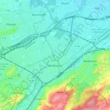
Name: Mulhouse topographic map, elevation, terrain.

Location: Mulhouse, Haut-Rhin, Grand Est, Metropolitan France, France (47.72188 7.28249 47.78337 7.36863)

Average elevation: 833 ft

Minimum elevation: 751 ft

Maximum elevation: 1,106 ft

Other topographic maps

Click on a map to view its topography, its elevation and its terrain.

Schweighouse

France > Grand Est > Haut-Rhin > Lautenbach

Average elevation: 1,634 ft

Schaeferhof

France > Grand Est > Haut-Rhin > Kembs

Average elevation: 810 ft

Gear up for your next adventure:

🏔️Mountain Trail Maps - High‑detail maps for popular peaks
🔊Portable Camp Speaker - Music and alerts at camp
🥾Men's Hiking Boots - Durable, waterproof footwear for rugged terrain and steep inclines
🧭Outdoor Navigation Book - Learn advanced navigation skills
🧭Compass with Lanyard - Easy‑carry compass for navigation

As an Amazon Associate, this site earns from qualifying purchases at no extra cost to you.