Geolocate

Rabenstein topographic map

Interactive map

Click on the map to display elevation.

About this map

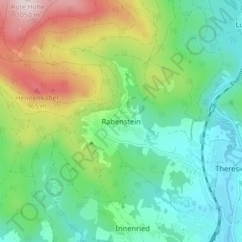
Name: Rabenstein topographic map, elevation, terrain.

Location: Rabenstein, Zwiesel, Landkreis Regen, Bayern, 94227, Deutschland (49.01994 13.18288 49.05994 13.22288)

Average elevation: 2,336 ft

Minimum elevation: 1,847 ft

Maximum elevation: 3,412 ft

Other topographic maps

Click on a map to view its topography, its elevation and its terrain.

Theresienthal

Deutschland > Bayern > Landkreis Regen > Zwiesel

Theresienthal, Zwiesel, Landkreis Regen, Bayern, 94227, Deutschland

Average elevation: 2,073 ft

Klautzenbach

Deutschland > Bayern > Landkreis Regen > Zwiesel

Klautzenbach, Zwiesel, Landkreis Regen, Bayern, 94227, Deutschland

Average elevation: 2,119 ft

Innenried

Deutschland > Bayern > Landkreis Regen > Zwiesel

Innenried, Zwiesel, Landkreis Regen, Bayern, 94227, Deutschland

Average elevation: 2,044 ft