
La Galerie topographic map
Interactive map
Click on the map to display elevation.
About this map
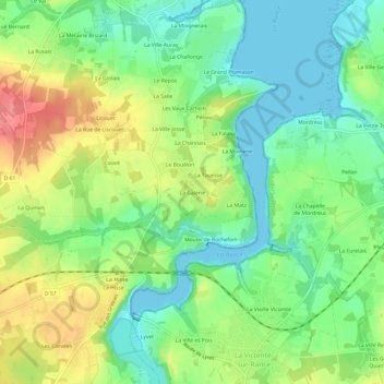
Name: La Galerie topographic map, elevation, terrain.
Average elevation: 105 ft
Minimum elevation: 0 ft
Maximum elevation: 269 ft
Other topographic maps
Click on a map to view its topography, its elevation and its terrain.
Les Vaux Grapins
France > Brittany > Côtes-d'Armor > Plouër-sur-Rance
Les Vaux Grapins, Plouër-sur-Rance, Dinan, Côtes-d'Armor, Brittany, Metropolitan France, 22490, France
Average elevation: 131 ft