Geolocate

Shilan topographic map

Click on the map to display elevation.

About this map

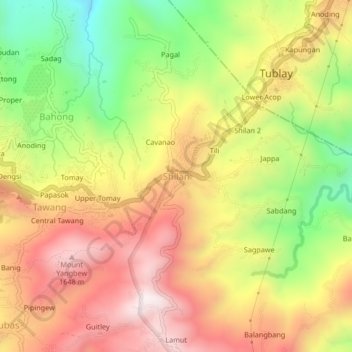
Name: Shilan topographic map, elevation, terrain.

Location: Shilan, La Trinidad, Benguet, Cordillera Administrative Region, 2601, Philippines (16.44315 120.60088 16.48315 120.64088)

Average elevation: 4,419 ft

Minimum elevation: 3,077 ft

Maximum elevation: 5,584 ft

Other topographic maps

Click on a map to view its topography, its elevation and its terrain.

Gear up for your next adventure:

🗃️Trail First Aid Kit - Essential kit for outdoor injuries and emergencies
🪓Survival Multi‑Tool - Versatile tool for camp and trail tasks
🪶Trail Camera - Capture wildlife on your hikes
🌎3D Topographic Globes - Raised relief globes for a tactile understanding of geography
😴Insulated Sleeping Pads - Compact and warm pads for high-elevation camping

As an Amazon Associate, this site earns from qualifying purchases at no extra cost to you.