
Make a donation
Gear up for your next adventure:
As an Amazon Associate, this site earns from qualifying purchases at no extra cost to you.
Ansonia topographic map
Click on the map to display elevation.
Make a donation
Gear up for your next adventure:
As an Amazon Associate, this site earns from qualifying purchases at no extra cost to you.
About this map
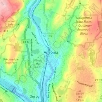
Name: Ansonia topographic map, elevation, terrain.
Average elevation: 249 ft
Minimum elevation: -16 ft
Maximum elevation: 636 ft
Naugatuck Valley Planning Region trails, hiking, mountain biking, running and outdoor activities
Make a donation
Gear up for your next adventure:
As an Amazon Associate, this site earns from qualifying purchases at no extra cost to you.
Other topographic maps
Click on a map to view its topography, its elevation and its terrain.
Oakdale Manor
United States > Connecticut > Naugatuck Valley Planning Region > Southbury
Average elevation: 279 ft
Kettletown
United States > Connecticut > Naugatuck Valley Planning Region > Southbury
Average elevation: 492 ft
Edgewood
United States > Connecticut > Naugatuck Valley Planning Region > Bristol
Average elevation: 341 ft
Millville
United States > Connecticut > Naugatuck Valley Planning Region > Naugatuck
Average elevation: 433 ft
Make a donation
Gear up for your next adventure:
As an Amazon Associate, this site earns from qualifying purchases at no extra cost to you.
Lakewood
United States > Connecticut > Naugatuck Valley Planning Region > Waterbury
Average elevation: 541 ft
Straitsville
United States > Connecticut > Naugatuck Valley Planning Region > Naugatuck
Average elevation: 479 ft
Lake Plymouth Dam
United States > Connecticut > Naugatuck Valley Planning Region > Plymouth
Average elevation: 692 ft
Hillcrest
United States > Connecticut > Naugatuck Valley Planning Region > Middlebury
Average elevation: 581 ft
Make a donation
Gear up for your next adventure:
As an Amazon Associate, this site earns from qualifying purchases at no extra cost to you.
Sunnyside
United States > Connecticut > Naugatuck Valley Planning Region > Shelton
Average elevation: 177 ft
Forestville
United States > Connecticut > Naugatuck Valley Planning Region > Bristol
Average elevation: 325 ft